Arriving on the South Island
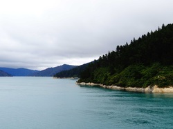
Ahhh, the south Island of New Zealand! For many it is THE destination of the country, with the North Island only getting a cursory few stops on the way down. Having had such an amazing time on the North Island, we were eager to see how the south would compare. It didn’t start favorably, as the ferry ride over Cook Strait was cloud ridden (though still pretty) and the rain started to fall once the driving started. We didn’t get far that first day, but were pleasantly surprised about our ability to freedom camp along the eastern coast in a little car park with a pleasant lakeside viewing platform.
The next morning our wildlife encounters began as we drove through the downpour to Ohau point, a known breeding grounds for the New Zealand fur seals. The little fellas could care less about the pouring rain, and as we watched amid the drenching we saw them frolicking about, both adults and cubs alike. What a wondrous introduction to New Zealand wildlife.
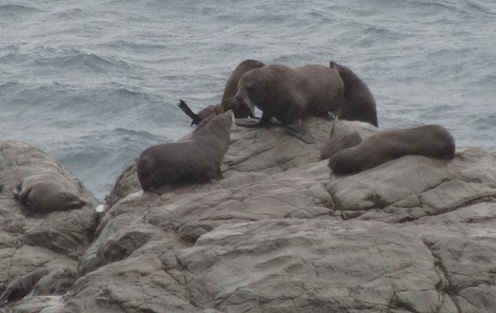
Cute fur seals lounging in the rain!
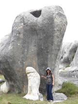
Strange formations at Castle Hill
From there, having to make some tough choices about where to go with the weather remaining relatively foul, we headed up a bit to Arthur’s Pass to see the city of stone that is Castle Hill. Featured in the “Narnia” films, this limestone outcropping features a variety of bizarre shapes and found us climbing and laughing at the various oblong shapes created! From there we bypassed the large city of Christchurch due to time and weather and along the way to Mount Cook stopped for a quick hike at the Rakaia Gorge.
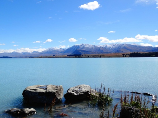
Beautiful Lake Tekapo
Then it was on to the main event! The weather started to clear as we drove west towards Mt. Cook, the tallest peak in New Zealand. Our first stop was the phosphorescent glowing waters of Lake Tekapo. The lake is glacier fed and as the water flows from the glacier to the basin of the lake, it grinds the surrounding rock into “flour”. This flour serves to refract the light in the lake, making it glow almost like ectoplasm! The view is even grander after a drive up to the hilltop observatory outside of town, where you can compare the glacier fed lake to the more typical Lake Alexandria.
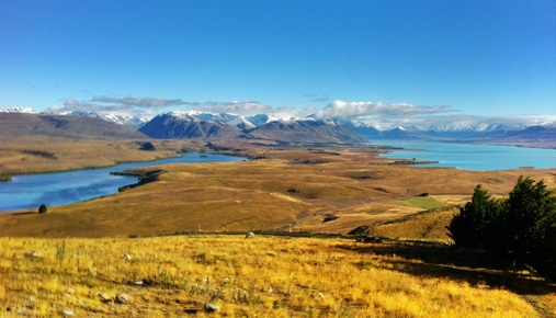
Lake Tekapo vs Lake Alexandrina
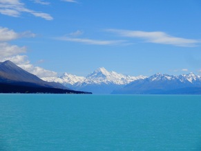
Lake Pukaki
After Tekapo, we drove the long length of Lake Pukaki on our way to Mount Cook. Lake Pukaki shares the same lineage as Lake Tekap so the 55km drive was pure delight on our first crystal clear day on the south island as we drove the turquoise waters with Mt. Cook beckoning from the horizon. If that was the ice cream, the cherry on top was arriving in the Mount Cook National Park and doing the glorious Hooker Valley walk, which passes several swing bridges before breaking views of the stunning Mount Cook holding court over the valley. We slept at the Mount Cook camp with the wind buffeting Faith (the name of our van) and dreaming of our humbleness before the rocky towers that the Australian and Pacific tectonic plates have created in their millennia long embrace.
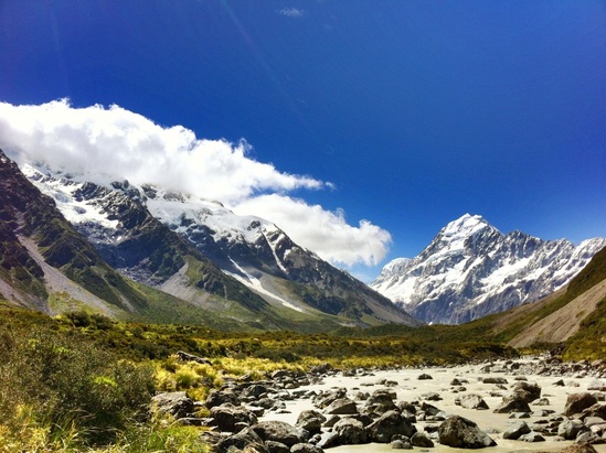
The stunning view of Mt. Cook, freshly capped with snow, as we turned the corner of the Hooker Valley Track
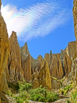
The Clay Cliffs outside of Twizel
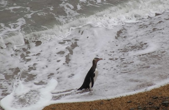
The next day saw us overwhelmed with what to do next as the weather in Mount Cook was already souring. A quick peek at the Tasman glacier was followed by a visit to the Clay Cliffs of Omarama. The experience was almost ruined for Neda when she was climbing behind me and I dislodged a soccer ball sized stone that nearly took her out. But the cliffs, which rose like a giant striated clay organ into the sky, were a sight to behold. Still, afterwards we found ourselves a bit frazzled as we drove towards the town of Oamaru, wondering how to make our schedule work. Now let me tell you a true piece of wisdom from the road – if you ever feel in a funk, find some penguins! For us, a drive off the coast outside of Oamaru to Bushy Beach at dusk was just the ticket. It is at this time in the evening that the world’s most rare penguins, the yellow-eyed variety, waddle up out of the ocean to bring food to their waiting chicks. Neda spotted one of the sea birds while it was still in the waves and we watched as it let the tides bring it to shore and started its ritual walk up the beach. How special to witness this nature made domestic ritual! We bedded down that night at a DOC (Dept. of Conservation) campsite, feeling amped up and recharged for our trip down the east coast of the south island.
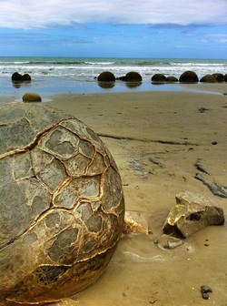
And it did not disappoint! In one of our best days of the whole trip, we hit all the high notes. A trip to Katiki point to start the day saw us surrounded by lounging fur seals and penguin chicks burrowed in their nesting holes off the hiking track. Wildlife was followed in quick succession by wild things as we bounded off to the famous Moeraki boulders, beach bound balls filigreed with quartz-like calcite crystals. If that wasn’t enough sexual allegory, our next stop was the peninsula at Shag Point, where a hidden tidal shelf holds mysteries of ages past. It is here that ancient dinosaur skeletons were discovered, having been entombed in spherical stone over the ages of sediment buildup. These “dinosaur eggs” were a delight to discover and explore.
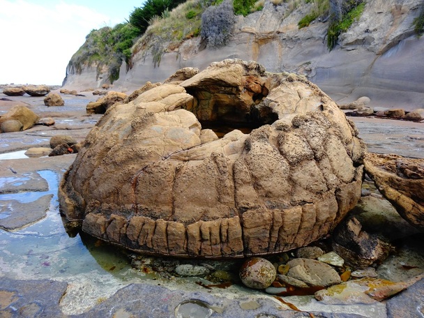
Sediment build-up like this at Shag Point led to the creation of these "dinosaur eggs" over millions of years - entombing goodies for scientists to discover years later, including NZ's largest dinosaur fossil of an 8 meter long Plesiosaur!
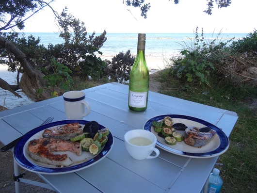
The night reached its apex down in the car park off of Shag Point, where we freedom camped with sweet little spot right on the beach. We partook in some Raglan hospitality as we watched the seagulls butcher a slew of fish on the beach before digging into our own delicious meal of pan fried local salmon, seared zucchini, and bottle of a local sauvignon blanc, the NZ specialty. We were thinking of our friend Jane back in Austin, who introduced us to delicious sauvs and grilled fish off the balcony of the Roc!
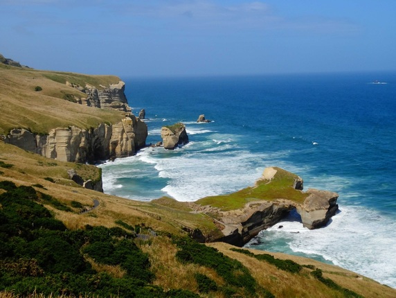
The wandering continued down the coast to Dunedin where a quick visit to the city’s Otago museum showed us the Plesiosaur that had been discovered at the aforementioned Shag Point. Then it was off to some hikes on the barren and majestic Otago peninsula where we stood on the edge of 300 meter drops at lovers leap, meditated at the chasm loop and finished off the day descending the homemade passageway through the rock to the beautiful tunnel beach. The waves thundered around us and the scenery swept us away, only to find us freedom camping at a cozy little surf beach in the tiny village of Brighton. The morning was a fine one for yoga and meditation on the shadow lapped beach and the cold public showers felt like a premium sauna after 3 days of roughin’ it!
The amazing tunnel beach also featured a scary land bridge (bottom right) that you could walk over while listening to the waves booming onto rocks beneath
I know this post seems likes a whirlwind, but trust me the real wind didn’t begin until we got down into the “Roarin’ 40’s” of the Catlins. This southernmost region of NZ is among the windiest part of the planet and it’s normal to see near horizontal trees who have been bent but not broken by the ceaseless airflow of the region. Though we stopped for a scenic hike to Jack’s blowhole (where we saw a penguin narrowly escape the sea surging waters), the true purpose of the journey might be have been our favorite spot of the whole trip – Curio Bay. The near southernmost part of the island, Curio Bay is one of the most unique places on earth. It has a tidal shelf which at low tide reveals the remains of a 170 million year old petrified forest that was preserved there after a volcanic eruption.
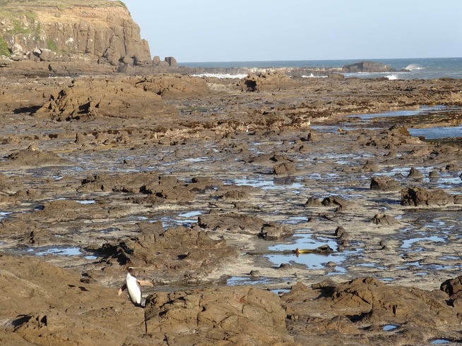
The eerie naturalistic landscape of Curio Bay - a petrified forest preserved by volcanic ash and only visible as the tide lowers each evening. The not-so-discerning eye will also notice our yellow-eyed penguin friend making his nightly stroll up the shelf with his gullet full of fish, ready to feed his molting chick!
If that wasn’t enough, the shelf is also home to the friendliest group of yellow eyed penguins on the island. We watched slackjawed as one of these rare penguins came within 10 meters of us, called to his chick, and then waited as the partially molted chick emerged from his burrow to retrieve the fish his parent was holding in his gullet. We watched this amazing feeding process up close! It was at once intimate, wild, and humbling to be given this window into these creatures’ lives.
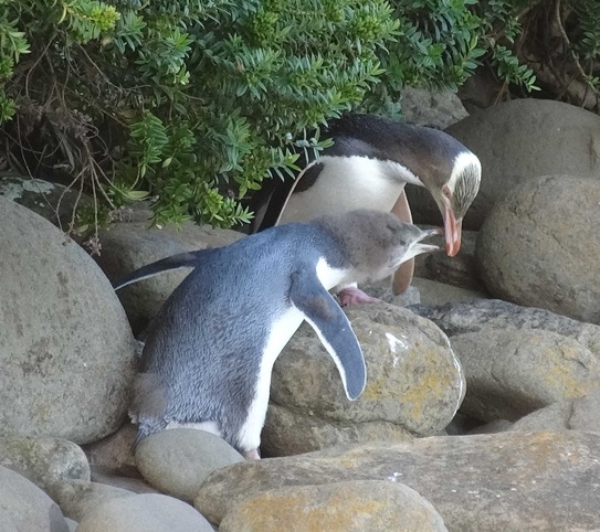
The eager chick gets his feeding. He is almost fully molted now and will soon be ready to go out into the wild. His final molting, however, created a cute little afro - see more pics on the flickr link below!
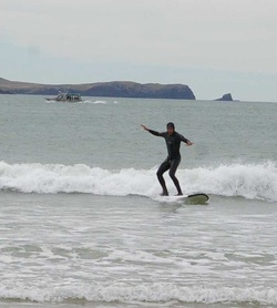
Jeff hangs 10...
This spot couldn’t get better right? Well it does. The adjacent Porpoise Bay, just a few minute walk away is home to a pod of the rare mini Hector dolphins, who feature a dorsal fin that resembles a Mickey Mouse ear. The Hector dolphins are somewhat unique not just due to their small size, but that they tend to live close to the shore, making for a good bet you can see them swimming there. For us the perfect solution came in Nick, the proprietor of the Catlin’s surf school. We took a surf lesson from him on a perfect windy day. Not only did Neda and I both get up and hang ten multiple times, we also got a show from the resident dolphins as they jumped around the waves while we surfed. It was endorphin overload to the max. Could anything top it? After all, it was the west coast of the South Island which receives all the hoopla…can’t wait to see what awaits!
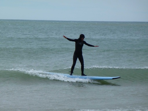
...but Neda shows him up!
To see all the amazing pics from Marlborough and Canterbury (the northern bit), click here.
To see all pics of Otago including the Moeraki boulders, Shag Point, and the Otago Peninsula, (the middle bit), click here.
To see all the pictures of the Catlins (the Southern bit) including Curio Bay and Jack's Blowhole, click here.
To see all pics of Otago including the Moeraki boulders, Shag Point, and the Otago Peninsula, (the middle bit), click here.
To see all the pictures of the Catlins (the Southern bit) including Curio Bay and Jack's Blowhole, click here.
 RSS Feed